
Liveable Streets Shadwell
Our Liveable Streets programme will improve the look and feel of public spaces in your neighbourhood. By creating a better environment, we can make it more convenient to get around by foot and bike.
Closed Submit your comments
- Project update
- Co-design Workshops
- Overview
- Early Engagement Results
- Next Steps
- Covid-19/Coronavirus Update
- Frequently Asked Questions
- Privacy Notice
Project update
Shadwell 2021
The Liveable Streets Shadwell public consultation is planned for Spring 2021, to gain the community’s feedback on the design proposals for the project area. At the commencement of the consultation period, every household and business within the project area will receive a consultation pack that includes an information leaflet detailing the proposals and a hard copy survey.
To stay up to date on the project, please visit:
Co-design Workshops
Help shape the future of your area
Earlier this year we heard from residents and businesses on how we can improve the streets around Shadwell to make walking and cycling easier for locals.
We will be holding a series of online co-design workshops in mid-September.
Overview
Our Liveable Streets programme will improve the look and feel of public spaces in Shadwell. The programme is part of the Love Your Neighbourhood initiative which aims to improve the area for all Tower Hamlets residents by making changes to the street infrastructure.
We will be working with the Shadwell community through every step of the programme to make the improvements you want to see.
Make sure to Have Your Say now and stay up to date with the programme and how you can participate by subscribing.
Map of the Tower Hamlets Liveable Streets programme area. Click to enlarge.
Early Engagement Results
In the early engagement stage we consulted with residents, businesses and other important stakeholders from within the area. This is done through:
- Online surveys
- Interactive maps
- Drop in sessions
- Business door-knocking
- Flyering
The early engagement phase of the Liveable Streets Shadwell programme ended early-2020.
Read the Early Engagement Report here.
View our engagement and consultation results below.

Next Steps
We are in the early stages of developing plans and hearing from the community in the Shadwell area.
After hearing your responses to our online survey and interactive map, we’ll be holding Co-design Workshops where you will be able to work with the project team to further develop the improvements you’d like to see.
Later in the year, these plans will be presented to the community for comment through a public consultation process prior to works commencing.
To stay up to date, make sure to subscribe.
Covid-19/Coronavirus Update
Our Liveable Streets programme team are following Government advice and are currently working remotely, work is continuing as planned on the projects and the team will adhere to all guidelines set out by the Government.
The programme is available for comment and feedback, so please get in touch with the team via liveablestreets@towerhamlets.gov.uk or phone us on 0203 092 0401
We will update the website with any changes to the programme and hope you will continue to help us improve the look and feel of your neighbourhood.
For Covid-19 updates from Tower Hamlets or to join our mailing list please click here.
Frequently Asked Questions
What is the ‘Liveable Streets’ programme ?
Our Liveable Streets programme will improve the look and feel of public spaces in your neighbourhood. By creating a better environment, we can make it more convenient to get around by foot and bike.
Our vision is to work with residents and businesses to create vibrant, safe neighbourhoods to promote travel by sustainable methods.
What does the programme aim to do ?
Improve the look and feel of public spaces.
Encourage more walking and cycling in the borough, especially for local trips.
Reduce rat-running in local residential streets.
Significantly reduce non-residential through traffic on local residential streets.
Improve air quality.
What are the benefits of the programme ?
For pedestrians:
A network of pedestrian-friendly, low traffic zones connected by formal crossing points, to make walking safer, easier and more accessible.
A more pleasant walking environment with improved footways, planting trees and shrubs, improved lighting and public art, to improve the attractiveness of walking routes and reduce fear of crime.
For cyclists:
A network of cycle-friendly, low traffic zones connected by formal crossing points, to make cycling safer, easier and more accessible.
Increase in cycle facilities, such as secure cycle parking at public transport hubs and retail areas, and cycle hangars in residential streets, to remove existing barriers to cycling and make cycling more accessible.
For businesses:
Improved public realm in retail areas to attract visitors.
Increase in footfall in retail areas, creating a boost for businesses in our town centres.
Provide seating, greening and tree planting to encourage customers to linger.
For residents:
Improved local streetscape with reduced noise and road danger.
Residents will be able to access better connected routes to the borough’s town centres and to neighbouring boroughs.
More opportunities to allow school streets, play streets and areas for local community events.
For road users:
The borough will be safer for all road users.
An increase in cycling and walking among residents will reduce demand on the local road network.
For everyone:
Less traffic will reduce emissions, improve air quality and road safety, and reduce noise pollution – creating a more pleasant environment for all.
Increase opportunities for physical activity.
More pleasant public spaces will make the borough more attractive to residents and visitors.
How will you increase the number of people choosing to walk or cycle ?
Providing safer, better-connected routes throughout the borough will enable people of all abilities and ages to walk and cycle. This will also be supported by promoting free cycle training and other relevant complementary measures.
How will this be achieved?
This will be done through a variety of on-street infrastructure projects across the borough, such as changes to road layouts to give priority to walking, cycling and public transport. These projects will be supported by complementary measures to promote active travel.
What is an active travel complementary measure ?
Complementary measures aim to reduce barriers to walking and cycling within the community.
Barriers include: lack of secure cycle storage in residential areas and public transport interchanges; safety fears about cycling; access to a bicycle; and maintenance of bicycles.
Complementary measures such as walking tours, historic walks, free cycle training, free access to Dr Bike (cycle mechanic) at council events, the installation of cycle hangars and hubs will help mitigate against these barriers. This will increase the number of users choosing sustainable modes of transport.
Have the project areas already been decided?
Yes. Please see the map below for details.
What areas does the programme cover ?
Seventeen areas were chosen, covering approximately 60 per cent of the borough. These areas have been split into four phases of work across the next four years. The map below shows the project areas and phases.
How were these areas selected?
The rationale for selecting these areas is:
Phase one: Substantial work on traffic management reviews has already been carried out in these areas prior to the Liveable Streets Programme beginning. Following public consultation several schemes have since been built. The public consultation generated many more suggestions for further public realm improvements and provides a strong basis for exploring further changes in these areas.
Phase two: These areas tie in with the council’s strategic plans which have been developed by the town centres team, as well as other traffic management reviews that are due to be implemented around the same time.
Phase three: Three of these areas are planned to tie in with known Transport for London (TfL) proposals for complementary measures, including cycle routes. New areas have been added to extend the geographical scope of the works into areas where there are known complaints and wider issues that need to be addressed.
Phase four: The areas in this phase seek to tie in with development master planning due for construction around this time.
When does each phase of the programme start and finish?
Details of the overall programme, including the dates for each phase and area, can be found on the Council’s website.
What kind of improvements might be implemented?
Improvement projects will vary in each area but are likely to include some of the following:
Widened footways.
Planting trees and shrubs.
Modal filters (features, such as bollards or signs, used to limit access to streets, to certain methods of transport) / road closures.
Parklets / pocket parks (parks created on small plots of land, that are accessible to the general public).
School Streets/play streets
What is the Love Your Neighbourhood App?
The Love Your Neighbourhood app enables residents and visitors to instantly tell the council about any issues that need addressing, such as graffiti, fly-tipping, broken play equipment, pot holes or over flowing bins.
Users simply take a picture of a problem and the app will pinpoint their location and send the details directly to our environmental contractors, ensuring that problems are dealt with swiftly.
The app also allows people to send pictures and share their thoughts on the many great aspects of the borough – anything from a special place or landmark, to a quirky shop or local character. Now on Google Play and the App Store.
How can residents and businesses be involved in the design of their local area?
Throughout the programme, there are several stages when residents and businesses can provide feedback on improvements they would like in their area.
Theses stages are:
Early engagement – Before designs are developed, residents and businesses will be able to provide comments and suggestions on an interactive map at the exact location.
Workshops – Residents and businesses can provide feedback to influence the design of their area.
Consultation – We request feedback on the proposed design that has been developed in conjunction with residents and businesses.
Implementation – If the projects are approved by the council, the design will be constructed over an agreed timescale.
Keep an eye on the website for information on how you can get involved.
Where can I submit my ideas?
For each project area, you can submit your ideas and views through an online survey. We will also be holding events throughout the programme where you can come and talk to us. More information on these events will be provided online as they develop.
Will I be notified when the engagement starts in my area?
Each area-based scheme will begin with an early engagement survey. A leaflet will be delivered to each household and business within the area, giving details on how to feed into this survey.
Schemes will also be promoted through the council’s existing communication channels.
Will there be more cycle facilities as part of the Liveable Streets programme?
Yes, one programme aim is to improve the cycle network around Tower Hamlets, increasing connectivity through residential areas and provide cycling facilities suitable for users of all ages and abilities.
How much will the programme cost and how is it being funded?
The overall budget for the 17 areas is £14 million and is being funded largely by London Borough of Tower Hamlets approved by the mayor.
The Shadwell area, which is in phase two, has also been successful in securing a Liveable Neighbourhoods bid funded by TfL, which could add up to £3.5m to the budget for that area.
Depending on the programmes agreed for delivery, there could be potential to bid for funding from a range of other funding opportunities.
Where can I find a map of the existing and proposed cycle routes in with borough?
The existing cycle map can be found here.
Tower Hamlets is working with TfL to create new routes through the Borough including Quietway 6 (Victoria Park to Barkingside), details can be found here. Cycle Future Route 5
TfL is proposing to introduce a new cycle route between Hackney and the Isle of Dogs via Westferry, Mile End and Victoria Park. It would connect with the cycle routes between Stratford and Aldgate and Barking to Tower Hill, as well as the proposed Rotherhithe to Canary Wharf crossing. Parts of this route are proposed through or alongside some Liveable Street areas, and it is expected that TfL will release further information for consultation on the route designs in the coming months.
What is a School Street?
A School Street is a scheme where traffic is moved away from the school gate to reduce the impact of vehicle emissions on children’s health and improve road safety. They may involve closing a road to traffic either permanently or at school opening and closing times, or introducing traffic management to discourage idling at the school entrance and reduce congestion.
By moving traffic away from the school gate we will deliver a safer, more pleasant environment for everyone using the street. At the same time we will maintain access for residents, businesses, pedestrians and cyclists and encourage trips to and from school to be made by sustainable modes.
How can my school apply for a School Street?
Twenty schools have already been prioritised for action, according to air quality statistics, Parking Action areas, the status of their school travel plans etc. In addition, other schools in the Liveable Streets project areas will be reviewed to potentially benefit from a School Street scheme.
Will buses be impacted by these projects?
Any works which may affect the bus routes will have to be agreed with Transport for London (TfL). Changes to any routes, bus stops or times can be found on the council and TfL website. We may implement measures to improve bus reliability and we will aim to not affect access to bus services or their reliability.
Will parking and loading be affected?
In some areas we may propose to reduce or reorganise car parking to allow the installation of additional cycle parking, new public spaces and infrastructure. Where parking reductions do occur, specific facilities (loading and disabled bays) will be installed to enable loading activity and improve accessibility for disabled users, to ensure businesses can be serviced and easily reached by all customers.
How will these projects impact emergency services?
When the council makes any changes to road layouts, the emergency services are included as statutory consultees. This means that the council must consult with them and if they raise objections about the proposals, the council must reconsider the plans.
Regular meetings will be held with the emergency services to allow them to inform us of any issues that are occurring in the new road layout. This will allow the council to mitigate against these issues promptly.
Where can I find the air quality levels for my area?
London Borough of Tower Hamlets operate four air quality monitoring stations in the borough. These are located at Mile End, Victoria Park, Millwall Park and, Blackwall Tunnel Approach. The Blackwall Tunnel approach monitoring station is managed by TfL for the council. They measure pollutants in real time which means that the pollution levels are constantly being measured and the results recorded. Results of real time monitoring can be found on the Air Quality England website.
The air quality forecast for Tower Hamlets can also be found on the Love Your Neighbourhood app.
Further questions
If you have any further questions about the programme, please feel free to contact us at: LiveableStreets@towerhamlets.gov.uk
Please click here for a PDF version of the FAQs.
Privacy Notice
This consultation is being carried out by Project Centre Limited for and on behalf of Tower Hamlets Council.
All personal data submitted in connection with the consultation is processed by Project Centre Limited on behalf of Tower Hamlets Council.
Any email updates that you opt in to receive will be delivered in accordance with Tower Hamlets Council’s GDPR privacy notice for newsletters. This can be viewed here.
Project update
Shadwell 2021
The Liveable Streets Shadwell public consultation is planned for Spring 2021, to gain the community’s feedback on the design proposals for the project area. At the commencement of the consultation period, every household and business within the project area will receive a consultation pack that includes an information leaflet detailing the proposals and a hard copy survey.
To stay up to date on the project, please visit:
Co-design Workshops
Help shape the future of your area
Earlier this year we heard from residents and businesses on how we can improve the streets around Shadwell to make walking and cycling easier for locals.
We will be holding a series of online co-design workshops in mid-September.
Overview
Our Liveable Streets programme will improve the look and feel of public spaces in Shadwell. The programme is part of the Love Your Neighbourhood initiative which aims to improve the area for all Tower Hamlets residents by making changes to the street infrastructure.
We will be working with the Shadwell community through every step of the programme to make the improvements you want to see.
Make sure to Have Your Say now and stay up to date with the programme and how you can participate by subscribing.
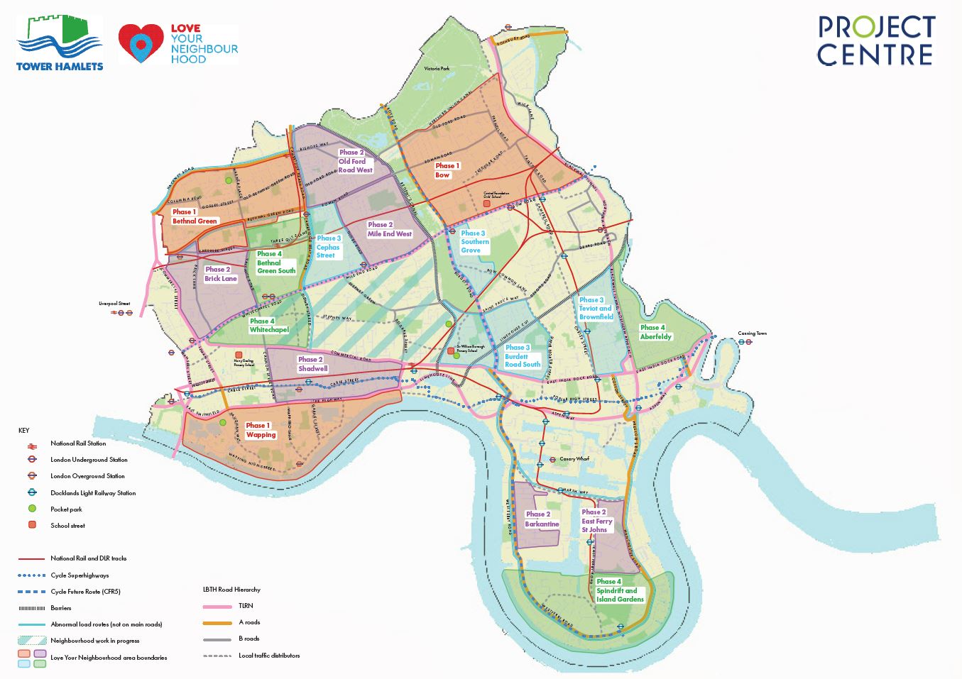
Map of the Tower Hamlets Liveable Streets programme area. Click to enlarge.
Early Engagement Results
In the early engagement stage we consulted with residents, businesses and other important stakeholders from within the area. This is done through:
- Online surveys
- Interactive maps
- Drop in sessions
- Business door-knocking
- Flyering
The early engagement phase of the Liveable Streets Shadwell programme ended early-2020.
Read the Early Engagement Report here.
View our engagement and consultation results below.
Next Steps
We are in the early stages of developing plans and hearing from the community in the Shadwell area.
After hearing your responses to our online survey and interactive map, we’ll be holding Co-design Workshops where you will be able to work with the project team to further develop the improvements you’d like to see.
Later in the year, these plans will be presented to the community for comment through a public consultation process prior to works commencing.
To stay up to date, make sure to subscribe.
Covid-19/Coronavirus Update
Our Liveable Streets programme team are following Government advice and are currently working remotely, work is continuing as planned on the projects and the team will adhere to all guidelines set out by the Government.
The programme is available for comment and feedback, so please get in touch with the team via liveablestreets@towerhamlets.gov.uk or phone us on 0203 092 0401
We will update the website with any changes to the programme and hope you will continue to help us improve the look and feel of your neighbourhood.
For Covid-19 updates from Tower Hamlets or to join our mailing list please click here.
Frequently Asked Questions
What is the ‘Liveable Streets’ programme ?
Our Liveable Streets programme will improve the look and feel of public spaces in your neighbourhood. By creating a better environment, we can make it more convenient to get around by foot and bike.
Our vision is to work with residents and businesses to create vibrant, safe neighbourhoods to promote travel by sustainable methods.
What does the programme aim to do ?
Improve the look and feel of public spaces.
Encourage more walking and cycling in the borough, especially for local trips.
Reduce rat-running in local residential streets.
Significantly reduce non-residential through traffic on local residential streets.
Improve air quality.
What are the benefits of the programme ?
For pedestrians:
A network of pedestrian-friendly, low traffic zones connected by formal crossing points, to make walking safer, easier and more accessible.
A more pleasant walking environment with improved footways, planting trees and shrubs, improved lighting and public art, to improve the attractiveness of walking routes and reduce fear of crime.
For cyclists:
A network of cycle-friendly, low traffic zones connected by formal crossing points, to make cycling safer, easier and more accessible.
Increase in cycle facilities, such as secure cycle parking at public transport hubs and retail areas, and cycle hangars in residential streets, to remove existing barriers to cycling and make cycling more accessible.
For businesses:
Improved public realm in retail areas to attract visitors.
Increase in footfall in retail areas, creating a boost for businesses in our town centres.
Provide seating, greening and tree planting to encourage customers to linger.
For residents:
Improved local streetscape with reduced noise and road danger.
Residents will be able to access better connected routes to the borough’s town centres and to neighbouring boroughs.
More opportunities to allow school streets, play streets and areas for local community events.
For road users:
The borough will be safer for all road users.
An increase in cycling and walking among residents will reduce demand on the local road network.
For everyone:
Less traffic will reduce emissions, improve air quality and road safety, and reduce noise pollution – creating a more pleasant environment for all.
Increase opportunities for physical activity.
More pleasant public spaces will make the borough more attractive to residents and visitors.
How will you increase the number of people choosing to walk or cycle ?
Providing safer, better-connected routes throughout the borough will enable people of all abilities and ages to walk and cycle. This will also be supported by promoting free cycle training and other relevant complementary measures.
How will this be achieved?
This will be done through a variety of on-street infrastructure projects across the borough, such as changes to road layouts to give priority to walking, cycling and public transport. These projects will be supported by complementary measures to promote active travel.
What is an active travel complementary measure ?
Complementary measures aim to reduce barriers to walking and cycling within the community.
Barriers include: lack of secure cycle storage in residential areas and public transport interchanges; safety fears about cycling; access to a bicycle; and maintenance of bicycles.
Complementary measures such as walking tours, historic walks, free cycle training, free access to Dr Bike (cycle mechanic) at council events, the installation of cycle hangars and hubs will help mitigate against these barriers. This will increase the number of users choosing sustainable modes of transport.
Have the project areas already been decided?
Yes. Please see the map below for details.
What areas does the programme cover ?
Seventeen areas were chosen, covering approximately 60 per cent of the borough. These areas have been split into four phases of work across the next four years. The map below shows the project areas and phases.
How were these areas selected?
The rationale for selecting these areas is:
Phase one: Substantial work on traffic management reviews has already been carried out in these areas prior to the Liveable Streets Programme beginning. Following public consultation several schemes have since been built. The public consultation generated many more suggestions for further public realm improvements and provides a strong basis for exploring further changes in these areas.
Phase two: These areas tie in with the council’s strategic plans which have been developed by the town centres team, as well as other traffic management reviews that are due to be implemented around the same time.
Phase three: Three of these areas are planned to tie in with known Transport for London (TfL) proposals for complementary measures, including cycle routes. New areas have been added to extend the geographical scope of the works into areas where there are known complaints and wider issues that need to be addressed.
Phase four: The areas in this phase seek to tie in with development master planning due for construction around this time.
When does each phase of the programme start and finish?
Details of the overall programme, including the dates for each phase and area, can be found on the Council’s website.
What kind of improvements might be implemented?
Improvement projects will vary in each area but are likely to include some of the following:
Widened footways.
Planting trees and shrubs.
Modal filters (features, such as bollards or signs, used to limit access to streets, to certain methods of transport) / road closures.
Parklets / pocket parks (parks created on small plots of land, that are accessible to the general public).
School Streets/play streets
What is the Love Your Neighbourhood App?
The Love Your Neighbourhood app enables residents and visitors to instantly tell the council about any issues that need addressing, such as graffiti, fly-tipping, broken play equipment, pot holes or over flowing bins.
Users simply take a picture of a problem and the app will pinpoint their location and send the details directly to our environmental contractors, ensuring that problems are dealt with swiftly.
The app also allows people to send pictures and share their thoughts on the many great aspects of the borough – anything from a special place or landmark, to a quirky shop or local character. Now on Google Play and the App Store.
How can residents and businesses be involved in the design of their local area?
Throughout the programme, there are several stages when residents and businesses can provide feedback on improvements they would like in their area.
Theses stages are:
Early engagement – Before designs are developed, residents and businesses will be able to provide comments and suggestions on an interactive map at the exact location.
Workshops – Residents and businesses can provide feedback to influence the design of their area.
Consultation – We request feedback on the proposed design that has been developed in conjunction with residents and businesses.
Implementation – If the projects are approved by the council, the design will be constructed over an agreed timescale.
Keep an eye on the website for information on how you can get involved.
Where can I submit my ideas?
For each project area, you can submit your ideas and views through an online survey. We will also be holding events throughout the programme where you can come and talk to us. More information on these events will be provided online as they develop.
Will I be notified when the engagement starts in my area?
Each area-based scheme will begin with an early engagement survey. A leaflet will be delivered to each household and business within the area, giving details on how to feed into this survey.
Schemes will also be promoted through the council’s existing communication channels.
Will there be more cycle facilities as part of the Liveable Streets programme?
Yes, one programme aim is to improve the cycle network around Tower Hamlets, increasing connectivity through residential areas and provide cycling facilities suitable for users of all ages and abilities.
How much will the programme cost and how is it being funded?
The overall budget for the 17 areas is £14 million and is being funded largely by London Borough of Tower Hamlets approved by the mayor.
The Shadwell area, which is in phase two, has also been successful in securing a Liveable Neighbourhoods bid funded by TfL, which could add up to £3.5m to the budget for that area.
Depending on the programmes agreed for delivery, there could be potential to bid for funding from a range of other funding opportunities.
Where can I find a map of the existing and proposed cycle routes in with borough?
The existing cycle map can be found here.
Tower Hamlets is working with TfL to create new routes through the Borough including Quietway 6 (Victoria Park to Barkingside), details can be found here. Cycle Future Route 5
TfL is proposing to introduce a new cycle route between Hackney and the Isle of Dogs via Westferry, Mile End and Victoria Park. It would connect with the cycle routes between Stratford and Aldgate and Barking to Tower Hill, as well as the proposed Rotherhithe to Canary Wharf crossing. Parts of this route are proposed through or alongside some Liveable Street areas, and it is expected that TfL will release further information for consultation on the route designs in the coming months.
What is a School Street?
A School Street is a scheme where traffic is moved away from the school gate to reduce the impact of vehicle emissions on children’s health and improve road safety. They may involve closing a road to traffic either permanently or at school opening and closing times, or introducing traffic management to discourage idling at the school entrance and reduce congestion.
By moving traffic away from the school gate we will deliver a safer, more pleasant environment for everyone using the street. At the same time we will maintain access for residents, businesses, pedestrians and cyclists and encourage trips to and from school to be made by sustainable modes.
How can my school apply for a School Street?
Twenty schools have already been prioritised for action, according to air quality statistics, Parking Action areas, the status of their school travel plans etc. In addition, other schools in the Liveable Streets project areas will be reviewed to potentially benefit from a School Street scheme.
Will buses be impacted by these projects?
Any works which may affect the bus routes will have to be agreed with Transport for London (TfL). Changes to any routes, bus stops or times can be found on the council and TfL website. We may implement measures to improve bus reliability and we will aim to not affect access to bus services or their reliability.
Will parking and loading be affected?
In some areas we may propose to reduce or reorganise car parking to allow the installation of additional cycle parking, new public spaces and infrastructure. Where parking reductions do occur, specific facilities (loading and disabled bays) will be installed to enable loading activity and improve accessibility for disabled users, to ensure businesses can be serviced and easily reached by all customers.
How will these projects impact emergency services?
When the council makes any changes to road layouts, the emergency services are included as statutory consultees. This means that the council must consult with them and if they raise objections about the proposals, the council must reconsider the plans.
Regular meetings will be held with the emergency services to allow them to inform us of any issues that are occurring in the new road layout. This will allow the council to mitigate against these issues promptly.
Where can I find the air quality levels for my area?
London Borough of Tower Hamlets operate four air quality monitoring stations in the borough. These are located at Mile End, Victoria Park, Millwall Park and, Blackwall Tunnel Approach. The Blackwall Tunnel approach monitoring station is managed by TfL for the council. They measure pollutants in real time which means that the pollution levels are constantly being measured and the results recorded. Results of real time monitoring can be found on the Air Quality England website.
The air quality forecast for Tower Hamlets can also be found on the Love Your Neighbourhood app.
Further questions
If you have any further questions about the programme, please feel free to contact us at: LiveableStreets@towerhamlets.gov.uk
Please click here for a PDF version of the FAQs.
Privacy Notice
This consultation is being carried out by Project Centre Limited for and on behalf of Tower Hamlets Council.
All personal data submitted in connection with the consultation is processed by Project Centre Limited on behalf of Tower Hamlets Council.
Any email updates that you opt in to receive will be delivered in accordance with Tower Hamlets Council’s GDPR privacy notice for newsletters. This can be viewed here.
Liveable Streets Shadwell area map
See what improvements the community want in Shadwell. Click on the icons on the map for more information.
Have your say
Early engagement for Shadwell is now closed
If you have any questions, please email us at LiveableStreets@towerhamlets.gov.uk

 Send us your thoughts by completing the form below.